


pt de montvert champlong de bouges

Nadia Sabatier
User
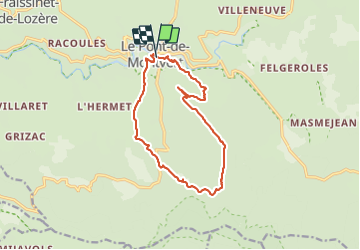

Length
13.8 km

Max alt
1160 m

Uphill gradient
449 m
Km-Effort
19.8 km

Min alt
874 m

Downhill gradient
440 m
Boucle
Yes
Creation date :
2022-03-06 09:22:10.507
Updated on :
2022-03-06 15:12:29.401
4h17
Difficulty : Easy

FREE GPS app for hiking
 SityTrail
IGN / Geographical institutes
SityTrail Plus
The world is yours!
About
Trail Walking of 13.8 km to be discovered at Occitania, Lozère, Pont de Montvert - Sud Mont Lozère. This trail is proposed by Nadia Sabatier.
Positioning
Country:
France
Region :
Occitania
Department/Province :
Lozère
Municipality :
Pont de Montvert - Sud Mont Lozère
Location:
Unknown
Start:(Dec)
Start:(UTM)
559303 ; 4912382 (31T) N.
Comments